18 Oct 2015
Bury Street Depot SUDS Project
For the last couple of weeks, we have been monitoring another of Enfield Council's wetlands projects; this time at the recently-vacated council depot at Bury Street West, Edmonton.
The project is the latest in a series of Sustainable Urban Drainage Schemes (SUDS), aimed at improving water quality and reducing flood risks in Enfield's water courses -- we recently monitored just such a project in nearby Pymmes Park, which uncovered a row of substantial second-world-war air raid shelters (summarised in last month's newsletter).
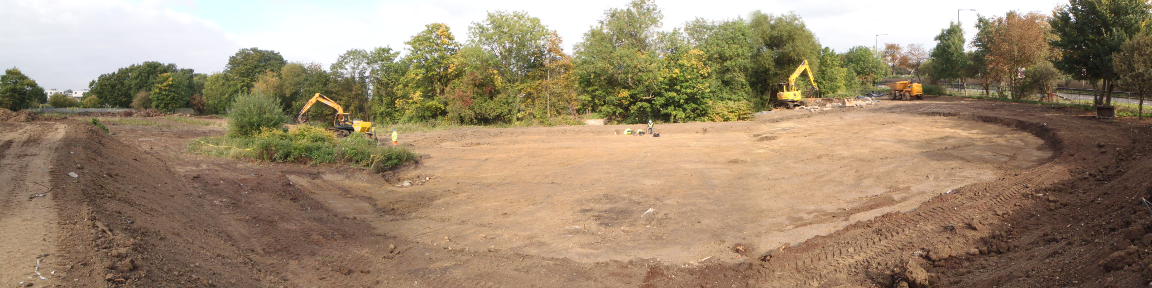
This wetlands scheme is focused on the southern half of the depot site; a long-abandoned tree nursery bounded on the north side by Salmon's Brook and on the east by the Great Cambridge Road (A10).
As elsewhere, the scheme will consist of a series of 'lagoons', through which storm water will flow; selected plantlife will reduce pollutants and improve oxygenation for wildlife. The surrounding ground will also be redeveloped to provide various wildlife habitats and will ultimately be linked to Bury Lodge Gardens.
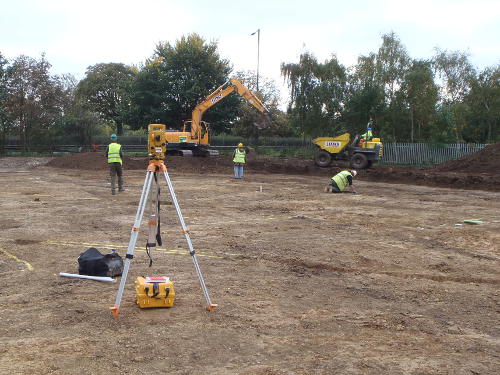
The work has involved machine stripping the area to be affected by the lagoons, and mapping and sampling the archaeological features revealed on the site: This is a more thourough approach than usual, and was suggested in light of previous work carried out on the site several years ago by Wessex Archaeology.
The depot is fairly close to a known area of Roman activity on the far side of the A10, and the Wessex dig tentatively identified a possible Roman or prehistoric ditch running through the site -- it was therefore suggested by GLAAS that a more detailed study of the site should be made, in case evidence of Roman habitation or industry stretched this far, perhaps along the course of Salmon's Brook.
Another point of interest in the site stems from the presence of several post-medieval land-drains: Not normally the cause of interest on our digs, the drains at Bury Street are of an unusual construction -- made by a narrow cut in the ground lined with the bone cores of cow horns, such drains have been recorded elsewhere in Enfield and are a feature perhaps unique to the borough.
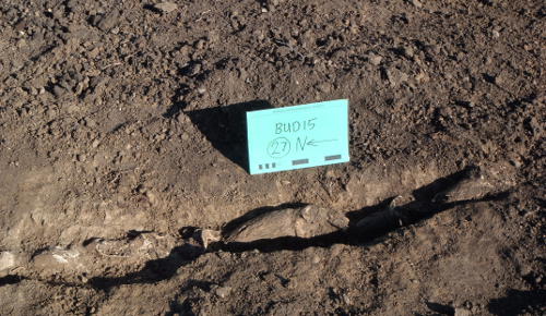
We eventually located and recorded four horn-core drains, running roughly parallel towards the north-east corner of the site towards Salmon's Brook (following the natural shallow fall of the site), spaced at seven-metre intervals.
The drains are cut into a uniform layer of dense brickearth, which evidently forms a watertight surface across the site leading to drainage problems in wet weather.
They are formed by a narrow cut in the brickearth, deepening towards the brook, and densely lined with cattle horn cores -- the centres of the cores consist of a honeycomb-like structure, which is much more permeable than the surrounding brickearth and so would have allowed water to soak along the channels ultimately into Salmon's Brook.
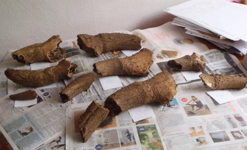
The most striking feature of the drains is the sheer number of horn cores involved -- the cuts run for at least 100 metres and are lined end-to-end with horn cores (all pointing south ('upstream')). The cores come in a variety of sizes, and from both long and short-horned animals. Although it is possible the cores were imported for the task, the focus of these drains on Enfield (previously recorded in Palmers Green in 1978, and more recently at Enfield Grammar School), strongly points to industrial scale processing of horn in the area, leading to large amounts of cores as waste material.
Ceramic and glass fragments in the drain cuts seem to point to an eighteenth-century date; so far we have been unable to identify a local horn-processing centre during this period, but this remains the subject of ongoing research.
Meanwhile, the putative Roman or earlier ditch unfortunately failed to materialise. We identified several 'paleochannels' -- ancient water channels formed by shifting meltwater and filled with sediments probably at the end of the last ice age. In section, these can strongly resemble man-made ditches, and it is almost certainly one of these that Wessex identified in their excavation.
There is, therefore, no evidence of any Roman activity on the site at all -- disappointing in a way but actually good news, since it means no significant archaeology will be disturbed by the wetlands scheme.
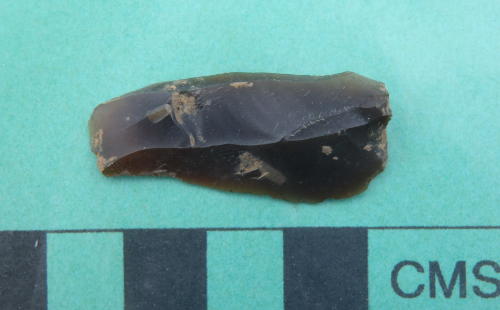
We did find several small flint tools ubiquitous to most sites, including two very nice mesolithic bladelets -- both still very sharp even after several thousand years in the ground -- this cheered us up considerably in the bouts of pouring rain during the first week!
The only other notable feature of the site was the remains of a substantial concrete structure -- so substantial that at first we speculated a WWII feature such as a gun position or even another air-raid shelter. Map research showed, however, the site was given over to allotments during the war, and prior to that a row of nursery greenhouses. A huge dump of glass and complete flowerpots confirmed it was indeed a (very big) greenhouse.
A detailed roundup of the work will eventually appear in the society newsletter.