26 Nov 2012
Forty Hall 'Greenway' Monitoring
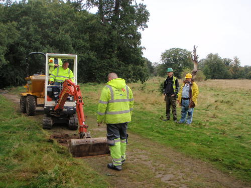
Since early October, the EAS has been monitoring work currently being carried out in Forty Hall by Enfield Council to create new gravel paths as part of the borough-wide "Greenways" programme.
The scheme is part of a London-wide initiative to create an extensive network of accessible paths for shared use by pedestrians, cyclists and wheelchair users away from heavy traffic.
There are several "Greenways" planned for Enfield, and more details about the project can be found here.
The path under construction in Forty Hall will run from Maidens Bridge, closely following the course of Turkey Brook, eventually through to Hilly Fields and beyond, including a short spur from Maidens Bridge along the east boundary of Forty Hall to the main car park.
The route along Turkey Brook of course carries the path very close to the former site of Elsyng Palace, and even the route of the spur from Maidens Bridge to the car park passes very close to known archaeology, such as the brick clamps excavated by the Society in 2005.
Since these areas fall within the protection of the Scheduled Ancient Monument, English Heritage has required the groundwork to be supervised and recorded by the EAS.
Although the path is being constructed in a fairly shallow cut (about 20cm), and in wooded areas with no cut at all, the wide area being covered is presenting the opportunity to (at least superficially) study several features, including some previously unexamined, and has even yielded one or two surprises.
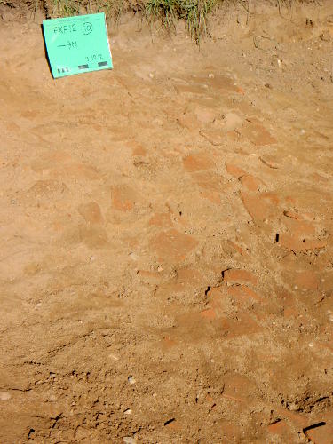
Our first surprise came early in the work, when the cut for the path revealed a linear tile surface following a break of slope just to the north of the car park. This may mark the edge of an artificial bank, and indicates that the grassy plateau next to the car park may be at least partly man made. The area by the car park was previously sampled by test pits by Northamptonshire Archaeology in 2010, and gave mostly negative results, so archaeology in this area was not anticipated.
We recovered several fragments of a large water pitcher associated with the tiles, which has been provisionally dated to 1480-1650. This raises the possibility of palace-era activity in the area, possibility related to brick making or other light industry at the fringes of the palace complex, and will likely be the subject of further research by the Society in the near future.
The most recent progress has brought the path along the brook close to the lime tree avenue, and across the projected line of the late fifteenth century vaulted brick palace drain excavated by the Society in 2005 and 2008, at a point near to the brook where water has been seen to discharge from the bank after periods of heavy rain.
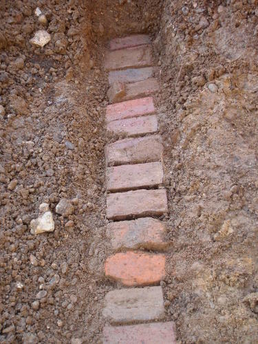
Expecting to find evidence at least for the construction cut of the drain, what we actually discovered was a small nineteenth century land drain.
It appears that at some point probably in the early nineteenth century, the palace drain collapsed or was damaged in this area, likely causing the field to flood and become very muddy. The palace drain seems to have been completely robbed out and replaced at this point with a small land drain, improvised from a mixture of recycled palace bricks and eighteenth and nineteenth century rubble.
While it is perhaps slightly disappointing not to have seen any more of the palace drain itself, it is reassuring to know that the new path will not pose any risk to palace archaeology in this area.
The exact extent of the modification to the palace drain is far from clear, and again will be a question for future research by the Society.
There have of course been many other small questions posed and answered by the ongoing work, the full details of which will be reported in future editions of the Society newsletter.
As the path is extended west, we expect it to cross close to the remains of the bridge and western-most water cascade, which we suspect may contain the remains of a redeposited palace midden. It will then cross the derelict water reservoir at the end of the lime tree avenue, before entering the pond groves and leaving the Scheduled Monument.
We intend to keep tabs on the work until it leaves the park altogether, but since no foundations will be cut in the wooded areas, we do not anticipate any significant archaeological implications.